Barn Island Wildlife Management Area - Sentinel Monitoring
Restoration of the Impoundments
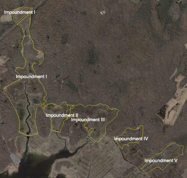
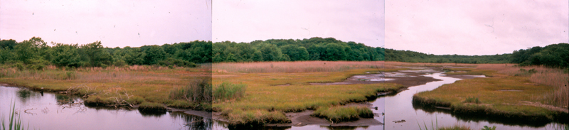
Shortly after acquiring lands and tidal wetland at Barn Island, the Connecticut Board of Fisheries and Game embarked upon the construction of four wildlife impoundments (see figure 1) as a means to offset habitat loss from mosquito ditching in 1931-32 and as a measure to address declining waterfowl populations in the Atlantic Flyway. At that time abandonment of mosquito ditches was not a politically acceptable management approach as the town of Stonington had paid for the construction of ditches. Various experts recommended the flooding of the marsh to facilitate increased use by waterfowl and shorebirds but also identified the importance of implementing various vegetation control practices to prevent the conversion of shallow open water to monoculture vegetation dominated by cat-tail. The primary measure for controlling vegetation was the use of various structures and inter-impoundment ditches to regulate water levels in a manner that might effect a reduction of cat-tail. In 1968, the fifth impoundment was constructed and impoundment 4 was connected to 5 via a channel. The purpose of the channel was distributed surplus freshwater between the two impoundments. None of these measures were effective and in the late 1970's the Wildlife Division of the CT Department of Environmental Protection consulted a plant ecologist in the Natural Resources Center for advice on vegetation management. It was recommended that tidal water be returned to the impoundments as cattail was particularly vulnerable to salt water.
|
| Figure 1. Location of the wildlife impoundments. |
In the 1970's, the field of restoration ecology was in its infancy and so various experiments were done with little or no scientific investigation. During the late 1970's, Hebard (1980) resurveys the vegetation and other biochemical properties of the impoundments and makes recommendations for the restoration of impoundments 1 to 3. Restoration projects today would first determine who much elevation was lost due to hydromodifications such as impounding and especially draining to tidal wetlands. In the later, draining and aeration of the organic soils promotes elevation loss sometimes on the order of several feet. Hebard (1980) documents the elevation difference between the impounded marshes and the adjacent natural or reference and found the following: imp. 1 (-1 cm), imp 2 (+1 cm), imp 3 (-4 cm), imp 4 and 4a (+4 cm) and imp. 5 (-2 cm). [Note Hebard consider the wetland between impoundment 4 and 5 as a previously unrecognized impounded marsh). Impoundments 1, 3 and 5 were lower than the corresponding reference marsh by 1 to 4 centimeters. These differences may merely indicate the under a non-tidal hydrological regime, the impoundments were not keeping pace with sea level rise. The higher elevations in impoundment 4a are likely due the dominance of non-tidal inland wetlands or sea level fen. Miller (1948) vegetation mapping shows that impoundment 4 was dominated by brackish meadow vegetation that may have been transitional to sea level fen. Clearly impoundment 4 was influenced by groundwater discharge and between impoundment 4 to 5, the glacial sediments are sandy outwash.
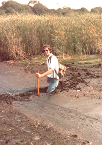
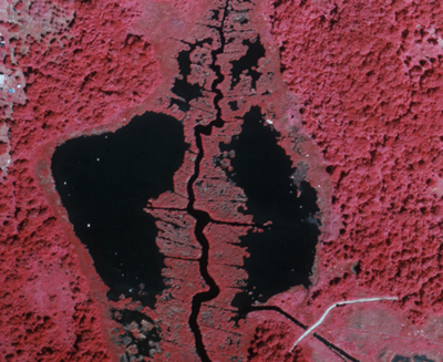
Impounding waters in a former tidal marsh reduces the aeration of the soil and raises the position of the 'groundwater'. Prolonged flooding of soil can result in unconsolidated soils (see figure 2).
|
|
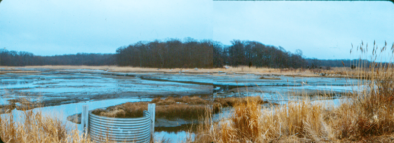
| Figure 2. Hebard (left) walking into a kidney shaped panne at low tide (right image - pool on the left side). Image source (left - September 1977; Hebard 1980, right - snapshot of 1974 summer false color infrared photography - Coastal Management Program, CT DEP). |
Hebard also observed that the impoundments were tidal and had varying degrees of saltwater present. THe water control structures at that time had weir boards, set at different height that allowed for the inflow of high spring tides but otherwise prevent the impoundments from draining at low tide.
Impoundment |
Year |
Action |
1 |
|
Tidal flow restored (weir boards removed)
7 foot diameter culvert installed |
2 |
1978 |
Tidal flow restored (weir boards removed) |
3 |
1987 |
Two weir boards removed in attempt to keep the former impoundment bottom exposed at low tide for wading birds and shorebirds |
4 |
1987 |
A 4 foot wide squash aluminum pipe is installed (dimension wider than the width of the pre-disturbance tidal creek). 1987 however is the first year that the vegetation would have detected the presence of salt water. |
5 |
1992 |
Tide gates removed and all weir boards were to be removed but apparently two weir boards were maintained in one of the two channels. |
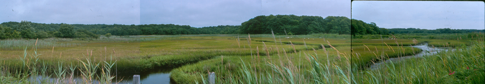
Figure 3 illustrates the vegetation changes in impoundment 1 following tidal flow restoration. The photo from 1974 shows the pre-restoration condition - here the dominant plant is narrow-leaved cat-tail (Typha angustifolia). The 1983 photograph is the year following the installation of the 7-foot diameter culvert into the dike. The vegetation with the gray appearance is dead Typha which succombs quickly to the reintroduction of polyhaline water from the bay. The culvert also drops the position of low tide causing the draining of the kidney shaped pannes in the middle of the marsh and these become colonized by Spartina alterniflora. By 1987, high marsh grasses have colonized the lower portion of the impoundment. Studies by Connecticut College confirmed the rapid disappearance of Typha throughout impoundment 1 but within this vegetation was colonies of the tall invasive grass Phragmites australis. However, with release of competition from Typha, the Phragmites colonies began to spread but ultimately these were intolerant of the high salinities in the impoundments. By 1996, must of the marsh was supporting salt marsh grasses and Phragmites had retreated to the marsh edge, were saltwater is diluted by groundwater discharge. Image year 2014 is to the west of the main channel and illustrates
|
|
|
|
|
| Figure 3. Photos of impoundment 1 in order from top to bottom 1974 (pre-restoration), 1983, 1987, 1996 and 2014. (Image sources William A. Niering except for 2014 - Rozsa). |
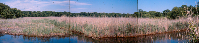
Tidal flow restoration was implemented in impoundment 2 in 1978 by removing weir boards from the half-round riser on the aluminum squash pipe and removing weir boards from the 32 inch diameter culvert. Figure 4 shows the revegetation change that had occurred by summer 1986.
|
| FIgure 4. Restoration of tidal marsh vegetation in impoundment 2 following tidal flow restoration 1978. The shallow pools that were pre-restoration impoundment have been replaced by stunted Spartina alterniflora. On the right side of the image, Phragmites australis is decreasing in height and density and retreating towards the upland. In the background there is a row of tall Phragmites that runs from right to left along fill placed on the marsh adjacent to a cross-ditch. |
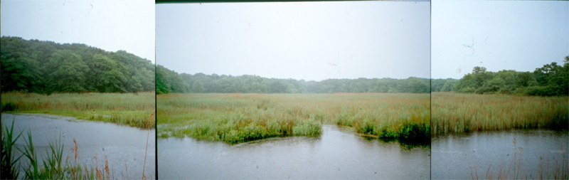
Removal of 2 weir boards in impoundment 3 (see figure 5) dropped the low tide position to more or less match the bottom of the former impounded area. The goal was to attempt to create some shallow water areas that would be used by shorebirds and wading birds while the increase in tidal exchange would increase the salinity and promote restoration of salt marsh vegetation while reducing the extent of Phragmites australis. The former hydrology created a a central impounded pond with a perimeter or bathtub ring of high marsh vegetation. The resulting change in hydrology allowed high marsh grasses to occupy lower elevations. The exposed pond bottom persisted through the 1990's until the slide gate on the side of the concrete chamber of the smaller culvert system fell into disrepair and the low tide position was lowered and the resulting aeration of the former pond bottom allowed from rapid colonization by Spartina alterniiflora.
|
|
| Figure 5. Top photo - shows the drainage of the impoundment from the removal of 2 weir boards. This action matched the low tide position to the bottom of the unvegetated impoundment. Bottom photo shows the colonization of the form pond that took place when the sluice gate on the second small culvert system was dislodged and dropped the position of low tide allowing for the rapid colonization of the flat by Spartina alterniflora. Photo credit Ron Rozsa. |
Impoundment 4 was reconnected to the tides in the fall of 1986 through the installation of a four-foot diameter aluminum squash pipe. The pipe was sized to be wider that the original meandering creek that provided tidal flow. A section of the natural creek south of the dike which was plugged with sediment was excavatated to the width of the culvert. This creek tied into two mosquito ditches that were cleaned where needed. The width of the creek has been reduced in width presumably a natural adjustment to the small volume of the tidal prism. The 1988 image (figure 6) shows the rapid response of Phragmites to the stresses of salty water. Impoundment 4 was originally a brackish meadow and reed marsh dominated by high marsh grasses and the reed three-square sedge (Miller 1948). The success of the impoundment 4 restoration has been mis-judged by the dike lookers - those that judge the vegetation condition by standing on the dry dike. However, to appreciate the vegetation changes in this marsh require walking through the marsh. Even though Phragmites is quite stunted today, when view from the dike it can hide patches of high marsh vegetation.
|
|
| Figure 6. Top photo shows the "graying" of Phragmites that is subject to salt stress. In the bottom photo Phragmites is decreasing in height and density by 1996. Middle left along side the creek is a large patch of Phragmites that has been converted to high marsh vegetation. Photo credit Ron Rozsa. |
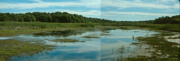
Tidal flow was restored to impoundment 5 in 1992 through the removal of downstream tide gates and upstream weir boards (most but not all). The resulting increase in salt water has eliminated Typha angustifolia and the invasive Phragmites australis is retreating toward the upland border.
|
|
| Figure 7. Pre-restoration impoundment 5 in 1990 (top photo). Note the extensive Typha angustifolia on the left side of creek and Phragmites australis on the right side of the creek. The bottom photo 1997 is taken at low tide and shows unvegetated flats in the center of the image and to either side the former impounded waters have been colonized by Spartina alterniflora. Typha has disappearred and Phragmites is retreating towards the upland margins. |
The sequential restoration of the impoundments at Barn Island created a unique opportunity to compare and contrast the restoration marshes against an adjacent control marsh to generate a trajectory that estimates the varying rates of return of ecological services particularly plant and animal species (Warren et. al, 2002). In general, within a restoring marsh, those locations that have low elevations with a high frequency of daily tidal flushing will be converted to low marsh dominated by Spartina alterniflora very quickly. Locations which have a flooding frequency that correspons with high marsh habitat, experience longer recovery times. The studies also indicate that different species of marsh invertebrates such as two amhipod species return to the restoring marsh at different rates. It takes 20 years for the salt marsh snail (Melampus bidentatus) to return to reference marsh values.
Literature Cited:
Miller, W. R. 1948. Aspects of waterfowl management for the Barn Island public shooting area. MS Thesis at University of Connecticut. 291 pp.
Warren, R. S., P. E. Fell, R. Rozsa, A. H. Brawley, A. C. Orsted, E. T. Olson, V. Swamy, W. A. Niering. 2002. Salt marsh restoration: 20 years of science and management. Restoration Ecology 10:497-513.
|