Barn Island Wildlife Management Area - Sentinel Monitoring
The Reverted Marsh
Miller and Egler (1950) note that "until a suitable area of preserved tidal-marsh becomes available for unbiased research and is allowed to revert to a natural equilibrium, many important problems must remain unsolved." Here the term revert is used to describe the return of the ditched marsh to the natural marsh, an equilibrium state. In the natural marsh module, the 1934 aerial photographs reveal that every colonial (farm) ditch formed levees at the creekward end of the ditch, creating a natural ditch plug which restores the continuous nature of the levee and the hydrology of the levee/basin marsh. This is the oldest evidence that demonstrates that aditched and drained marshes can revert to the pre-ditching levee and basin landscape. It is likely the case that as the ditch aggrades, the creekward end becomes so short that basin no longer drains and over levee flooding is restored.
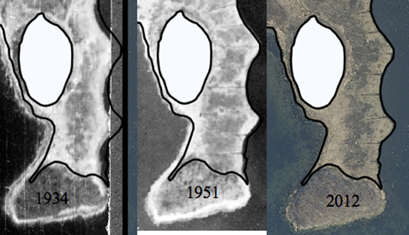
These same arrowhead features were found at the Sassfras Marsh section of Barn Island, a penisula marsh between Sassafras and Middle Islands. Figure 1 shows the post ditching shrinkage of the levees and the growth of new levees on the eastern and western shores. The western levee is 27 meters wide whereas the eastern levee is only 14 meters wide. In 1979 all of the Barn Island ditches were cleaned with an amphibious rotary ditching machine. However at Sassafras Island marsh, the western levees had filled the western ends of the ditches and the levee was not reditched. This intervention did however retard the reversion process. The eastern levee appears to be enlarging for there is 7 meters of mixed Spartina patens and Distichlis spicataat the western edge of the levee which is a transition vegetation. This likely become pure S. patens in the near future. A vegetation transect was created in the center of the marsh in 2016. The vegetation between the levees is stunted Spartina alterniflora and so this marsh has returned to levee - basin landscape. The S. patens of the levee is virtually pure in marked contrast to the description of the S. patens community of Miller and Egler (1950) - which is really a transition vegetation where S. patens colonized panne vegetation. There is almost no forb panne vegetation in the marsh and it may be that if there were forb panne community created during the shrinkage of the levees, then the new levee growth may have displaced forb panne vegetation. Coring would confirm the historic vegetation types.
|
| Figure 1. In this time sequence, Sassafras Island is on the bottom of the images and Middle Island is the white polygon near the top. Notice the shrinkage of the levees between 1934 and 1951 and the levee expansion in 2012. |
There is some trace amounts of Juncus gerardii on portions of the levee but other the levees are pure S. patens. To the west of Sassafras Marsh is a small narrow natural marsh peninsula. The peninsula is so narrow the two levees of each shoreline have merged into a single levee with no basin between. What is curious about that marsh is it is pockmarked with small circular ponds, less than a meter in diameter.
|
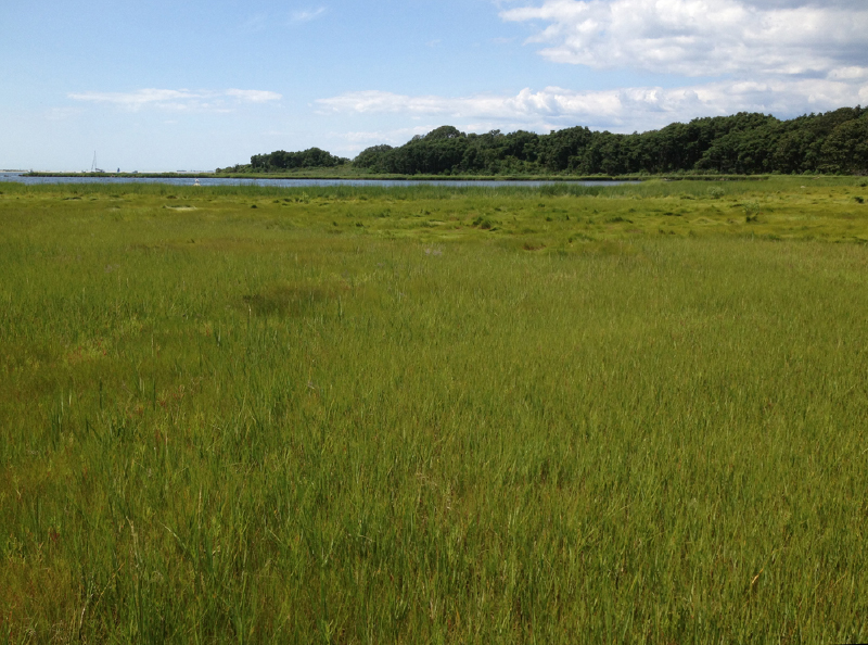
| Figure 2. Vegetation of Sassafras Island marsh. Spartina alterniflora stunted is in the foreground and the Spartina patens levee is in the background. View is looking westward, across the cove is a large forested island called Barn Island. (Photo source: R. Rozsa). |
A second marsh at Barn Island also appears to be reverting. This is the marsh downstream of dike 5, the lower portion of the Brucker Marsh. All of the ditches upstream of the dike are completely filled with sediment and vegetation. From aerial photographs, it is apparent that there is new levee growth at the creekward ditch margins. On closer inspection these levees are dominated by tall Spartina alterniflora but S. patens is colonizing these low levees.
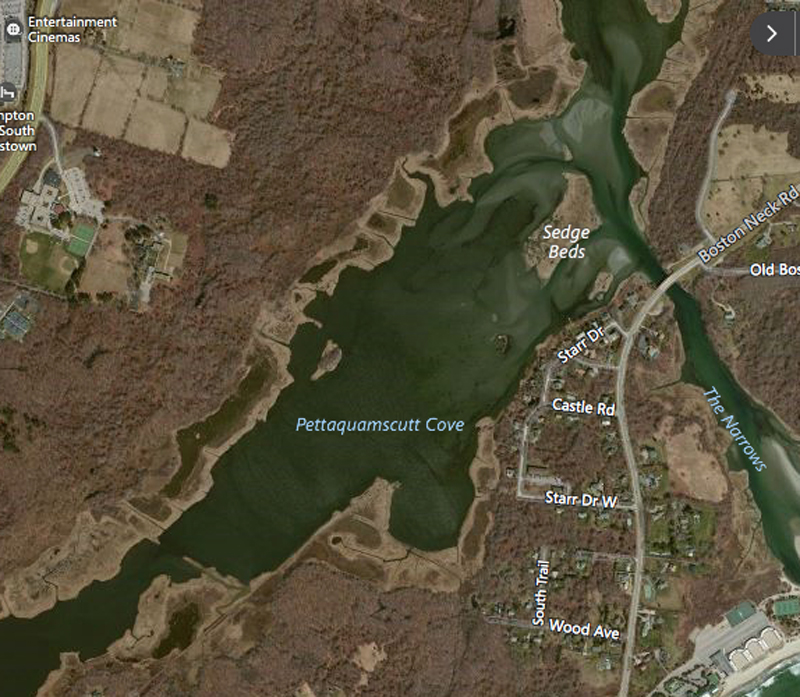
While searching for an image of the unditched marsh in Rhode Island known as Succotash Marsh, the marshes in the nearby Pettasquamcutt Cove have the appearance of reverted marshes. There are the wide and continuous creekbank levees and basins between the levees and uplands. There are prominent levees alongside the seaward ends of ditches with the characteristic arrowhead shape when viewed on aerials.
|
| Figure 3. Pettasquamcutt Cove appears to support a series of reverted marshes based upon the presence of wide and continuous levees and high marsh plain vegetation that supports the panne sequence. (Image source: Bing Maps) |
A similar pattern was located to the west of Barn Island at the former Stonington airport (see figure 4).
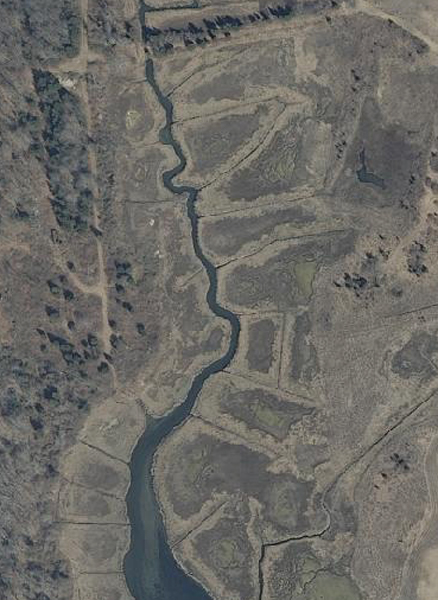 |
Figure 4. All segments of the airport marsh appear to be reverting to the levee and basin landscape. S. patens is dominant on at the creek and ditch banks and the interior basin vegetation is predominantly stunted S. alterniflora. Source 2012 aerial photograph.
|
Below dike 1 is an old colonial or farm ditch constructed to drain the basin and induce the spread of S. patens (see figure 5.). Coleman maps a significant portion of the marsh between the dike and the colonial ditch as DS/JG/FORB. Distichlis spicata is the dominant grass with lesser amounts of J. gerardii and lesser amounts of forb panne vegetation. By 1987, this mapping unit throughout lower Palmer Neck Marsh becomes forb panne as the levees continue to shrink. The 2012 aerial photographs suggest new levee formation. Inspection in 2016 confirms the new levee growth and the dominant grass is Spartina patens.
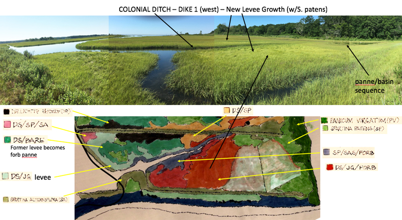 |
Figure 5. Shown here is a portion of the Palmer Neck Marsh just south of dike 1 as mapped in 1976 by Coleman (1978). The legend for mapping units list plants species in order of abundance from left to right. Nearly half of the marsh is designated as DS/JG/FORB. That area in 2016 has formed new levee and supports S. patens. (photo source: R. Rozsa).
|
Ron Rozsa - June 1, 2016. Revised September 5, 2016.
Citations:
Coleman, W.B. 1978. Vegetation of the Wequetequock-Pawcatuck Marshes Stonington, Connecticut - A Comparative Study 1948 and 1976. Masters Thesis, Smith College, MA.
Miller, W., and F. E. Egler. 1950. Vegetation of the Wequetequock-Pawcatuck tidal marshes, Stonington, Connecticut. Ecological Monographs 20:143-172.
|