Barn Island Wildlife Management Area - Sentinel Monitoring
Acquisition
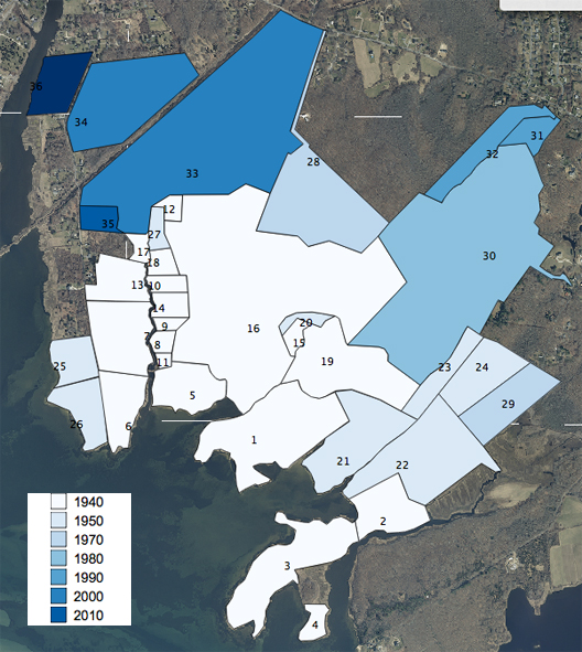
In the 1940’s, waterfowl populations were declining in the Atlantic Flyway and wildlife biologists where identifying approaches to improve waterfowl habitat. The Connecticut Board of Fisheries & Game began the acquisition of tidal wetland and adjacent uplands at Barn Island from 1944 to 1946 (see figure 1). Nineteen parcels were acquired for a total area of 423.7 acres. The largest parcel is the Vargas Farm (#16). Original ownership of these parcels was largely land divided amongst the Stanton and Palmer families. The neck at the west side of the Barn Island Shooting areas is Palmer’s Neck in honor of the original settler Walter Palmer.
Table 1 contains a listed of parcels and dates of acquisition.
|
Figure 1. Acquisition history of parcels at Barn Island by decade. |
“The lands were purchased to provide a public shooting ground and a wildlife management area. The state assumed the area would also furnish a certain amount of recreation of the public for picnicking, swimming, boating, shellfishing, and fishing during the seasons it was not being utilized as a hunting area.” (Miller 1948).
The area was expanded in the 1950’s, especially from 1950 to 1953 with 7 acquisitions. One hundred and forty-four acres were acquired, the largest being the Brucker Farm parcels (#21 and 22). A portion of the wetlands would become the last area to be impounded in 1968.
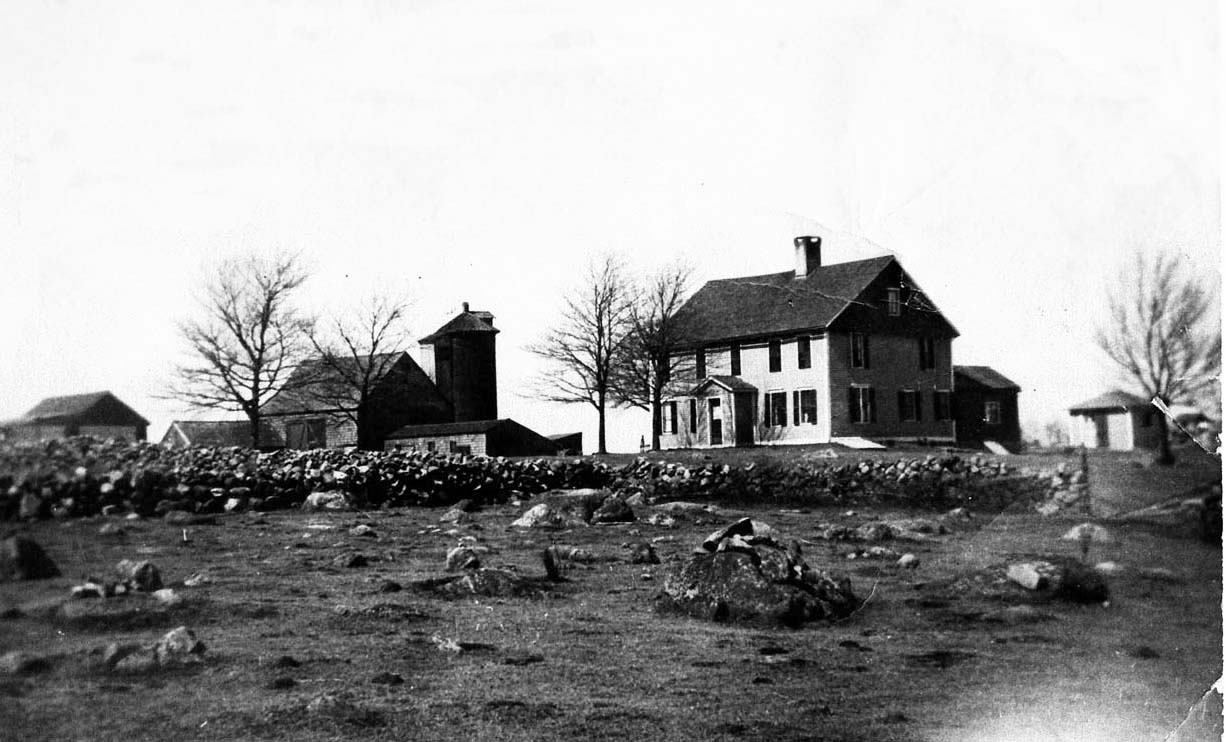
Only one parcel would be acquired in 1960, the Stewart Farm (see figure 2) of 150 acres (#30).
|
| Figure 2. The Stewart Farm purchased by G. Russell Stewart in 1909. In the foreground is one of the pastures. The house was built circa 1713 by Thomas Stanton. A portion of the foundation is still visible at the parking area off Stanton Road. (Photo credit Stanton Family). |
Two parcels of land were acquired in the 1970’s adding an additional 73 acres. In 1990, two small parcels were added increasing the area by 24 acres.
Two parcels were purchased in the 00’s including Manousos (144 acres; #33) at the head of impoundment 1 and Crowley (49 acres; #34) on the north side of this impoundment. A golf course had been proposed for the Manousos property.
Table 1. List of parcel acquisitions arranged by date and alphabetically by owner name. |
Parcel # |
Owner |
Acreage |
Date |
1 |
Barber, I.M. |
51.05 |
6/20/44 |
2 |
Barber, I.M. |
18.71 |
6/20/44 |
3 |
Barber, I.M. |
37.26 |
6/20/44 |
4 |
Barber, I.M. |
4.7 |
6/20/44 |
5 |
Clark, L.R. |
18.07 |
6/20/44 |
6 |
Hazard |
16.1 |
6/24/44 |
7 |
Hazard |
25.21 |
6/24/44 |
8 |
King, H.A. |
2.96 |
8/18/45 |
9 |
Lincoln, M.N. |
2.23 |
12/45 |
10 |
Lincoln, M.N. |
4.11 |
12/45 |
11 |
Lincoln, M.N. |
1.34 |
12/45 |
12 |
Mell, M.C. |
3.13 |
12/7/45 |
13 |
Miner, L.H. |
14.36 |
6/29/45 |
14 |
Nothe, R.H. |
5.56 |
11/20/45 |
15 |
Stearns, L. |
3.36 |
8/31/45 |
16 |
Vargas, F.A. & J.A. |
172.33 |
6/20/45 |
17 |
Lema |
3.16 |
1946 |
18 |
Miner, W.A. |
4.27 |
10/29/46 |
19 |
Stewart, G.R. |
39.37 |
2/8/46 |
20 |
Randall, G.W. |
3.14 |
4/19/50 |
21 |
Brucker, C.V. |
33.07 |
11/10/53 |
22 |
Brucker, C.V. |
46.32 |
11/10/50 |
23 |
Davis, J.L. & S. |
11.39 |
4/19/50 |
24 |
Davis, J. & Gabrielson, M.L. |
20.4 |
4/19/50 |
25 |
Haxzhurst & Johnson |
11.6 |
6/4/52 |
26 |
Oat, C & Palmer, S. |
14.79 |
5/20/52 |
27 |
Bindloss, J.B. |
4.18 |
10/15/57 |
28 |
Stewart, C.H |
152.3 |
6/8/64 |
29 |
Davis, J.L. |
51.43 |
1/70 |
30 |
Davis, J.D. |
21.36 |
7/21/70 |
31 |
Davis, L.M. |
7.34 |
4/24/91 |
32 |
Davis, L.M. |
16.46 |
4/24/91 |
33 |
Manousos |
145.35 |
7/16/04 |
34 |
Crowley |
48.6 |
2007 |
35 |
Matson |
5.75 |
2010 |
|