Barn Island Wildlife Management Area - Sentinel Monitoring
Conceptual Marsh Migration Module for Salt Marsh Complexes in southern New England
Scientists have long known that tidal marsh grow vertically and horizontally in response to sea level rise. One horizontal component of marsh vegetation/habitat change is the marsh migration/transgression onto the adjacent uplands. As sea level rises, the lower seaward slope of the ‘upland’ is subject to increased tidal flooding which introduce the seeds of tidal marsh plants resulting in the gradual conversion of upland vegetation to tidal marsh vegetation.
Descriptions of the actual marsh migration processes are largely absent in the ecological literature. A series of long-term vegetation studies conducted at the Barn Island Wildlife Management Area beginning in 1947 provide the basis for the description of the marsh migration model for salt marsh complexes presented here. The marsh migration process described here has been observed at many locations in Connecticut and also documented at a photostation in Harwich, Cape Cod (2002 to 2007). This model is supported by observations at many sites in Connecticut and locations on Cape Cod and southern New York.
The Biophysical Setting:
The module presented here only applies to salt marsh complexes where the dominant vegetation grows on soils with a polyhaline water chemistry and supports vegetation of the salt marsh series (Nichols, 1920). Marsh migration is the rapid (?) conversion upland vegetation to tidal marsh. The common upland vegetation affected by marsh migration is the Panicum-Baccharis community, at least post clearcutting by colonial farmers. Most of the time (all of the time?) this community is a non-tidal wetland influenced by groundwater or freshwater seepage at the base of a slope and the position of the groundwater table changes in response to sea level rise. This is a grassland or mixed grassland shrub community. The dominant grass, Panicum virgatum is the 'slough' form of switch grass (Ecker et. al, 2015). The boundary between this community and the next is approximated by the highest tides of the year in October. The location of this community is not fixed but rather migrates uphill/landward in response to sea level rise (Miller & Egler 1950, Coleman 1978). In 2014 and 2015, there has been active migration at the east end of dike 5 onto the top of the dike, formerly upland.
In most illustrations of a southern New England salt marsh, the upland border of consists of a narrow belt dominated by the Juncus-Argentina community. This zone is influenced by groundwater discharge and the soil water chemistry ranges from oligohaline to mesohaline. This is a grassy meadow and the dominant graminoid is black grass (Juncus gerardii) which is actually a rush likely introduced from Europe. Juncus avoids soils with a polyhaline water chemistry and seeks either high ground or low salinity habitats. Silverweed (Argentina anserina) is a differential species as it never occurs in salt marsh plant communities and thus can substitute for a refractometer and help the plant ecologist to immediately identify brackish marsh communities. Nowhere in the ecological literature will one find a reference to the ephermeral nature of this community which becomes a nearly pure stand of rush over a short period of time (a few years) and then it 'erodes'.
Marsh Migration:
Miller and Egler (1950) refer to marsh migration as follows “on a time-scale to be correlated with physiographic change, one must assume that the Juncus belt has gradually moved landward. In this respect, it has slowly invaded the Panicum border on the upper side, and has been invaded by the Spartina patens community on the lower side”. Seven decades of vegetation observations at Barn Island reveal predictable cycles of change. The formation of a nearly pure belt of Juncus gerardii heralds the end of the most recent marsh migration episode and the width of that belt represents the amount of upland converted to tidal marsh in the last 20 year period. Over glacial till at Barn Island, these belts are typically but a mere 1-2 meters wide!
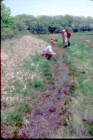
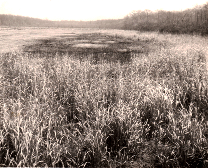
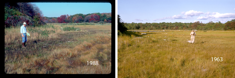
In 1976, Coleman (1978) noted that the Juncus belt was absent on at the Headquarters Marsh section of Barn Island. Dr. William Niering led a field trip to Barn Island in May of 1983 and the Juncus belt had formed but was entering a stage of 'degradation' - changing into a feature that resembled a foot path (see figure 1). Within the course of seven years, Juncus emerges as a prominent plant community. in 1976, seaward of the Panicum belt was forb panne (3rd photo from the top) in the location of the former Juncus belt (the Juncus belt of circa 1960's). Today, forb panne is the vegetation stage seaward of the Panicum belt. In 1947, there was no Juncus belt at the Headquarters marsh as evidenced by the absence of Juncus at photostation 14.
|
Figure 1. The dark green vegetation in the middle of the slide with a path in the center is the dark green Juncus gerardii belt in May 1983. Note the prominent belt of Panicum virgatum to the left of the 'path'. Twenty years earlier, the seaward edge of the Panicum belt would have occupied the Juncus where the path is and the Juncus belt would have been located to the right of the path. Today the Panicum belt is gone but the wetland in its place is the Nyssa forested wetland. In the understory of this forest, a new Juncus belt is forming. (Photo credit: William Niering) |
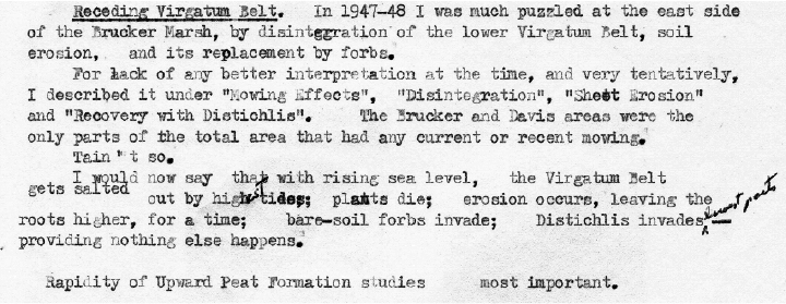
Egler (1974) revises his interpretation of the cause of the vegetation changes at the edge of the marsh (see figure 2).
|
| Figure 2. A snapshot of text from Egler’s 1974 field trip notes to Barn Island describing the marsh migration process. |
Fascinating that Egler notes the rapid formation of peat! In an attempt to understand the relationship between tides and vegetation change at Barn Island, Dr. Scott Warren would slice and dice the tide guage record from the nearby New London tide gauge with the program excel. This included examining different time periods. An early observation was that in the 1990's, sea level was rising at ~14 mm/yr! Another analysis examined changes in the tidal range which reveals an increase in the tidal range during the first half of the metonic cycle followed by a decrease in the second half. At the New London gauge - the variation in mean tidal range was 6 centimeters. The metonic cycle is the likely driver of the rapid peat building that is associated with the formation of the Juncus belt.
Erosion Phase of New Marsh:
Following the formation of a new Juncus belt on former non-tidal upland, the Juncus belt degrades or erodes. This begins a predictable process of vegetation change within the boundaries of the tidal wetland and does not result in the formation of new wetland. Miller and Egler (1950) observe the erosion of the Juncus and Panicum belt in 1947 at the Brucker Marsh section (see figure 2) and describe the succession that follows. Figure 19 of that publication shows the same erosion at photostation 14 on the Headquarters Marsh. Gross (1966) would observe the same erosion in 1964-65 (see figure 2) and called this "eroded edge", an analogue of the 1947 for with the cessation of mowing and grazing, these could not be the same phenomenon.
|
|
| Figure 2. Top photographs shows erosion in the Juncus and Panicum belts at the Brucker Marsh in 1947. (Photo credit: Miller 1948). Proposed location of impoundment 5 - construction of the impoundment would not occur until 1968. Bottom photograph (Photo credit: Alfred Gross) shows the return of the erosion in 1964 (Gross 1966). the short grass in the center of the erosion is Distichlis spicata and to the left is stunted Spartina alterniflora. The location is north of where the present day dike is. |
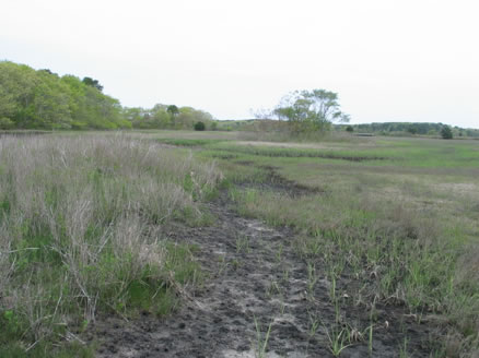
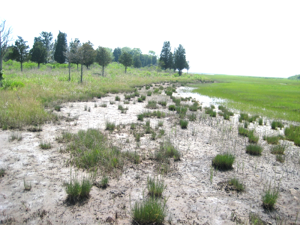
The eroded edge is observed in 1983 (see figure 1 above) and in 2008 at the Brucker Marsh (figure 3 below). In 2008, the Juncus belt was absent at the Brucker Marsh and in the fall, the 'path' would form elsewhere in the marsh. There erosion at Brucker is several meters wide and this is likely the result of the substrate being outwash sands. Groundwater discharge is one likely cause of the peat erosion and the porous sands here may be responsible for a zone of erosion that is wider than that of the glacial till areas such as the Headquarters Marsh were a mere path forms. Juncus peat erosion has been observed around individual boulders and the likely cause of erosion is intense rainfall.
|
| Figure 3. Eroded edge in 2008 on the east side of Brucker Creek south of dike 5. Panicum belt is to the left and stunted Spartina alterniflora panne is on the right. The exposed substrate is outwash sand dotted with small hummocks of Panicum virgatum peat supporting tufts of Triglochin maritima. In the lower slope of the eroded edge water is ponding and here grows Distichlis spicata. (Photo credit: Ron Rozsa) |
What causes the loss of the Juncus belt? One possibility is the phase of the metonic cycle wherein the tide range contracts which would make the Juncus peat aerobic and subject to decomposition. The alternative is increasing salt content of the soil caused by increased flooding associated with sea level or elevation of the groundwater table caused by sea level rise reduces groundwater flows to the Juncus belt and the soil salt content increases.
In the aftermath of the erosion, there are small mounds of Panicum peat present. The dominant roots in the peat are those of Panicum virgatum. This was observed in 2008 at Brucker Marsh and 1988 at the Headquarters Marsh. The erosion at Brucker Marsh exposed the underlying glacial sands and in the summer of 2015, Dr. Scott Warren noticed that the dominant fiddler crab here was Uca pugilator, the crab of sandy soils. It is very likely that every 20 years, the exposed of glacial sands at Brucker creates ideal habitat for this species.
Forb panne and Distichlis phase of the eroded edge:
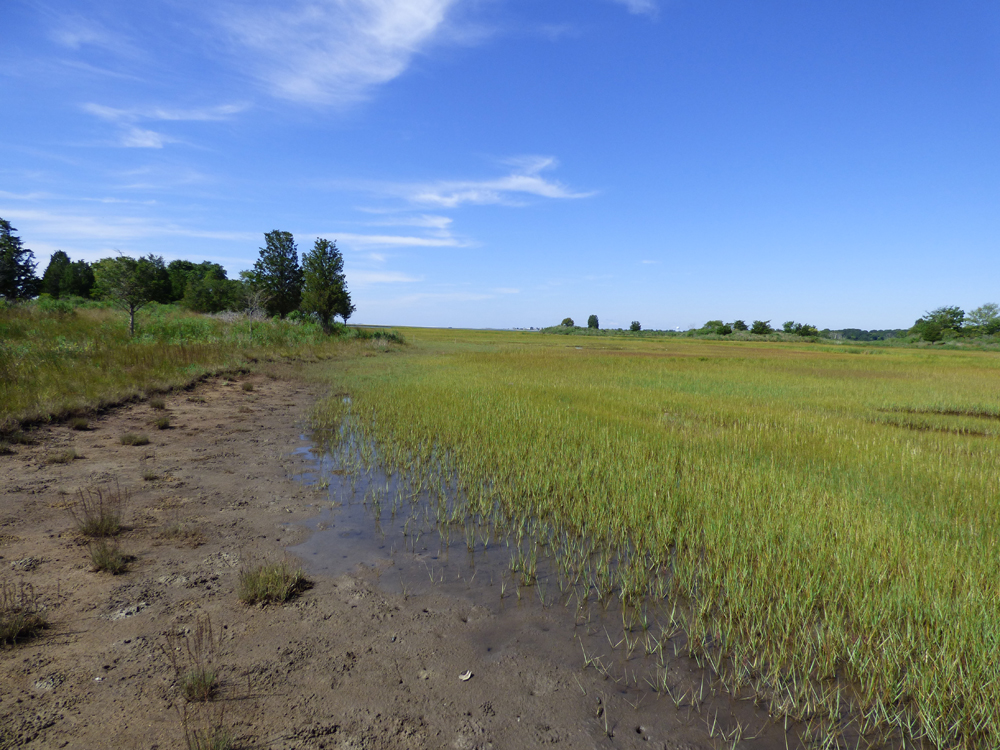
Miller & Egler (1950) and Gross (1966) note that the upper slope of the eroded edge becomes colonized by forb panne and the wet lower slope is colonized by Distichlis spicata (see figure 3 above). Seaward of the Distichlis in this figure is stunted Spartina alterniflora panne (SAS). Forb panne always occurs at a higher elevation than SAS panne. By 2015, the Distchlis had been displaced by stunted Spartina alterniflora spreading from the adjacent SAS panne (see figure 4). By the time the Juncus belt reforms, the entire eroded edge will have been transformed to SAS panne.
|
| Figure 4. The Distichlis growing in the lower seaward portion of the eroded edge during 2008 is replaced by stunted Spartina alterniflora from the adjacent marsh by 2015. To the left of the eroded edge, the lower seaward slope of the Panicum belt is now mixed Panicum and Juncus. (Photo credit: Ron Rozsa) |
Miller & Egler (1950) had forecast that the eroded edge of 1947 would ultimately be replaced by S. patens. At that time, much of the high marsh plain panne vegetation had been replaced by S. patens as a result of the drainage caused by grid ditching in 1931 and 1932. By 1964 however, S. patens had reverted to SAS panne at Brucker and Gross (1966) and so the eroded edge lay between SAS panne and the Panicum belt as was the case in 2008.
|
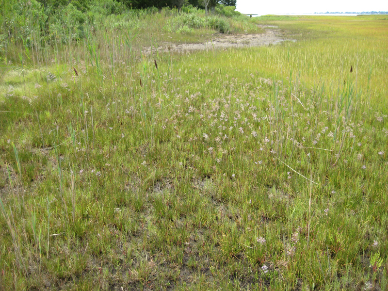
| Figure 5. Forb panne occupying the former upper slope of the eroded edge. (Photo credit: Ron Rozsa) |
Figure 6 shows Dr. Warren left in 1988 and Dr. Egler right in 1963 describing the forb panne at the same location on the Headquarters Marsh, although the two panne locations are positioned several meters apart as a result of marsh migration. The Panicum belt behind Dr. Warren is absent today and has been replaced by a dense stand of Iva frutescens. Egler (1974) noted that Iva was new to the border of the Headquarters Marsh and appears to colonize older Panicum belt.
|
| Figure 6. Dr. Warren (left photo) and Dr. Egler (right photo) are both describing the forb panne at the ~same location on the Headquarters Marsh. In the background is impoundment 2. The forbe panne on the left lies landward of the forbe panne on the right. (Photo credit: William Niering). |
Reading the marsh - the stages of marsh migration:
As noted above there is a predictable series of vegetation change that occur every ~20 years. The culmination of migration is the formation of the Juncus - Argentina belt, Juncus is the dominant species. In figure 7, the top image reveals a marsh on Cape Cod where the Juncus belt had eroded in 2002. At this stage, we can predict that Juncus will begin the process of colonizing the lower slope of the upland, above the eroded edge. The bottom photo in Figure 7 illustrates the new marsh migration zone forming in the understory of Iva frutescens as indicated by the increasing prominence of the Juncus. It is apparent that SAS panne is colonizing the lower slope of the eroded edge.
In Connecticut, it is not uncommon to find Iva with an understory of Juncus, but this is merely a transition community. As time progresses, the Juncus is found landward of the I and the I will then have an understory of SAS panne. At this stage the Iva is stressed and dying. As suggested by Egler (1974), Iva appears to colonize the older, lower portions of the Panicum belt and today the Iva is patchy. In a revision to the description of the Panicum belt at Barn Island, Iva is not a species of the Panicum belt, a non-tidal freshwater wetland. The dominant shrub of the Panicum belt is Baccharis halimifolia. A former expansive Panicum-Baccharis wetland was examined in Madison on the East River. Present throughout much of this wetland was Iva. It appears that the Panicum wetland is in transition to becoming tidal wetland, that will in the near future be dominated by Iva. Additional descriptions of the Panicum-Baccharis community are needed to determine if this is a non-tidal wetland and whether the presence of tidal species are solely associated with the next marsh migration zone. Similar, most studies of the relationship of Iva to the tidal marsh and Panicum-Baccharis community are needed.
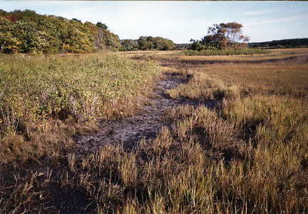 |
Figure 7. Herring River, Harwich, Cape Cod, MA. Top photograph is 2002 and showing the eroded edge lying seaward of a healthy stand of Iva frutescens. Bottom photograph is 2007 showing the colonization of the eroded edge by stunted Spartina alterniflora and the invasion of the Iva by Juncus gerardii. The Iva is stressed and dying. |
 |
Marsh migration into forests.
When Connecticut purchased land at Barn Island in the mid-1940's, most of the upland was farmland or pasture. In this photo of the Headquarters Marsh (1953), one can see the open character of the vegetation but nearly 10 years following acquisition, shrubs are becoming more prevalent in the abandoned fields. In most locations at Barn Island where the salt marsh intersects the upland, the upland supports a narrow band of non-tidal wetland which may be either grassland, shrubland or forested. The Panicum-Baccharis community has decreased significantly since the 1940's as forests have replaced much of the pasture and farmland.
The Nyssa - Doellingeria forested wetland community is a newly described plant community based upon a large depression sandwiched between impoundment 1 and 2. In most instances however, the community is a narrow belt that averages 5 meters in width. The tree sour gum or tupelo (Nyssa sylvatica) is the dominant tree. Other trees that may be found here are red maple (Acer rubrum) and swamp white oak (Quercus bicolor). The transition from this community to Oak-Hickory forest is abrupt at all physiognomic units (trees, shrubs and herb layers).
Since 2005, Juncus has been migrating into the lower seaward slope of the Nyssa-Doellingeria community. Juncus is evidently tolerant of dense shade. Other tidal wetland plants present are bent-grass (Agrostis stolonifera) and beaked spikesedge (Eleocharis rostellata). The surface water chemistry is oligohaline. In places the Nyssa appears stressed but the stress might be caused by changes in the position of the vadose zone associated with sea level rise. This stage is a transitional vegetation but it also a tidal wetland community which is flooded by the tides and supports tidal wetland species.
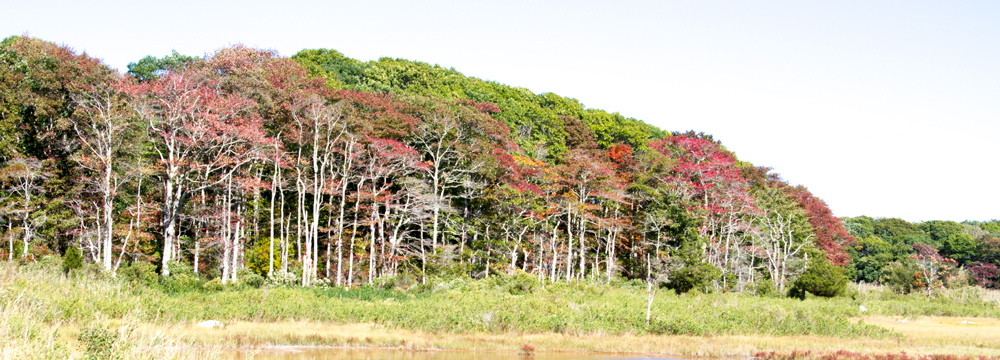
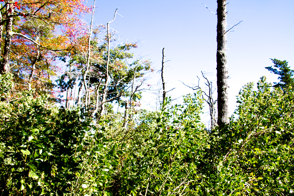
In at least two locations at Barn Island, the Headquarters Marsh and a long-linear forest belt between dikes 4 and 5 (see figure 8), Nyssa trees on the lower seaward slope are dead and devoid of branches. This mortality is estimated to be over 10 years old based upon the conditions of the trees and height of understory shrubs such as Baccharis.
|
|
| Figure 8. Topmost photo is a view of the seaward edge of the forested wetland between dike 3 and dike 4. The red foliage are the leaves of Nyssa sylvatica, which turn red in September. The bottom photo shows the canopy condition and the tall understory of Baccharis halimifolia where the trees have died. |
At this time the following three plant community types are recognized:
- Nyssa - Doellingeria forested wetland. This is the non-tidal forested wetland dominated by Nyssa. Between impoundment 1 and 2 there is an extensive non-tidal basin sandwiched between tidal wetland. Nyssa is the dominant tree but associates include swamp white oak (Quercus palustris) and red maple (Acer rubrum). There is a prominent shrub understory with species such as high blue blueberry (Vaccinium corymbosum), winterberry (Ilex verticillata), and sweet pepperbush (Clethra alnifolia). The herbaceous layer is diverse but the characteristics species include tall-white aster (Doellingeria umbellata), cinnamon fern (Osmunda cinnamomea), several Carex species and goldenrods Solidago rugosa and patula).
In September, Doellingeria is in flower and forms a distinct understory cover averaging 4 to 5 feet in height.
- The typical forested wetland of the lower upland slope however is a narrow belt several meters wide. There are fewer shrubs and herbs in any location but Doellengeria continues to be a diagnostic species. These are typically narrow belts, several meters wide and on the upslope side change abrupty into Oak-Hickory mesic forest.
- Nyssa - Juncus forested tidal wetland. This tidal wetland community forms where the Panicum belt has disappeared or failed to form under the canopy of Nyssa. Irregular tidal flooding introduces soil water into the surface and creates an oligohaline to low mesohaline water chemistry. Here as elsewhere, Juncus is the pioneer species in the marsh migration zones and is evidently tolerant of shade. Other tidal species present include Agrostis stolonifera, seaside goldenrod (Solidago sempervirens) and Iva frutescens. (Note - more relevees needed to describe the plant species and their abundance).
- It is postulated that groundwater discharge and the depth of rooting by Nyssa protects the trees from the influences of salt water. Nyssa does not appear to be tolerant of salt in soil water nor has it been observed to colonize oliohaline tidal wetlands.
- This is the common tidal phase of the above listed community and this condition has been present since 2008. It is forecast that this phase will become the community listed below in the next 10 years or less.
- Nyssa - Baccharis shrubland. The Nyssa trees on the seaward slope from dike 3 to 4 are all dead, lacking many branches and supporting an understory that has a number of plant species of the Panicum fen including Baccharis which forms a tall, dense shrub layer and Elymus virginicus. (Note, more detailed relevee descriptions are needed to describe this stage). It is estimated that the trees have been dead for 10 or more years.
- A likely cause of tree mortality is the changing elevation/vertical position of the vadose zone in response to sea level rise. Trees and shrubs are dying in the Panicum fen inside impoundment 3 where there is no influence of salt water. Hydrological and water chemistry studies are needed to understand the role of the groundwater properties and the influence of salt water upon roots of trees.
Literature Cited:
Coleman, W. B. 1978. Vegetation of the Wequetequock-Pawcatuck Marshes Stonington, Connecticut - A Comparative Study 1948 and 1976. Smith College, MA. 130 p.
Ecker, G., J. Zalapa and C. Auer. 2015. Switchgrass (Panicum virgatum L.) genotypes differ between coastal sites and inland road corridors in the Northeastern US. PLOS ONE 10.1371:1-15.
Egler, F. E. 1974. Barn Island Field Trip Notes.
Gross, Alfred C. 1966. Vegetation of the Brucker Marsh and the Barn Island Natural Area, Stonington, CT. Connecticut College, MS.
Miller, W., and F. E. Egler. 1950. Vegetation of the Wequetequock-Pawcatuck tidal marshes, Stonington, Connecticut. Ecological Monographs 20:143-172.
Page Content: Created by Ron Rozsa, page revised 4/20/2016.
|


